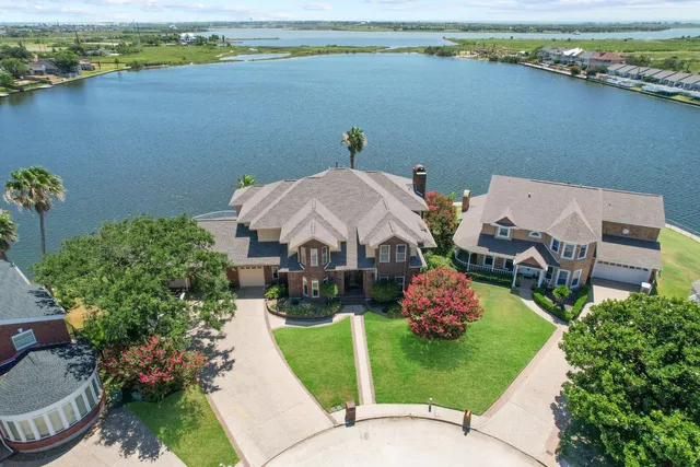
Imagine showcasing your property with breathtaking, bird’s-eye views that leave potential buyers in awe. Aerial drone photography empowers you to do just that!
Gone are the days when stunning aerial shots were limited to luxurious, high-budget properties alone. Today, drone photography helps create captivating visual content for all real estate listings.
Even hard-to-photograph features, such as sprawling lawns or elevation differences, can now be beautifully captured by drones flying at various heights and angles.
Embrace this modern real estate marketing technique and watch your property stand out from the competition!
Efficient Large-Scale Property Surveys
Nothing compares to the ease and efficiency of surveying extensive commercial or residential lands using aerial drone photography. Compared to traditional ground-based surveys, drones greatly reduce time-consuming on-site visits and expedite property sales.
They capture highly accurate images and data from overhead – invaluable information for potential buyers interested in landscape details, infrastructure opportunities, or environmental concerns.
For example, global engineering firm Atkins used a drone-mounted camera system called Site Scan by 3DR to swiftly perform site inspections on Birmingham’s prestigious Centenary Square project.
This helped identify and address construction issues early on, avoiding costly delays and providing progress reports with ease.
Enhancing Virtual Property Tours
In an age where online browsing is increasingly common, virtual property tours have become all the more crucial. Drones effortlessly provide high-quality images and smooth drone videos of your property, giving potential buyers an immersive experience they won’t forget.
Incorporating aerial photos into these tours also adds a unique perspective on property layout – valuable information that’s hard to capture through traditional ground-based photos.
Comprehensive Site Analysis Benefits
Aerial drone photography boasts another vital advantage: comprehensive site analysis for developers or investors looking into land acquisitions or project feasibility studies.
By capturing complete overviews of properties and their surroundings, drones provide invaluable insight into factors such as traffic patterns, neighboring developments, zoning limitations, and environmental concerns.
In turn, this information empowers data-driven decisions that drive successful real estate projects.
Accurate Property Line Demarcation
Disputes over property lines are no longer a headache with aerial drone photography to the rescue! Drones offer precision that is critical when determining boundaries or defining property extents – a feat otherwise challenging with ground-based photos.
These accurate aerial images not only minimize disputes but also help create clear legal documents related to property transactions and land registration processes.
Time and Cost Savings Potential
Investing in aerial drone photography can significantly save time and money on marketing campaigns for your property listings.
The days of hiring expensive equipment or employing a licensed pilot to capture aerial images are long gone. Advanced drone technology delivers high-quality images at a fraction of the cost of traditional methods.
Moreover, real estate agents can quickly acquire new perspectives by adjusting camera angles or flight paths on demand – something cumbersome and costly via conventional methods.
Attracting Tech-Savvy Buyers Market
A growing segment of tech-savvy buyers is entering the real estate market today. They’re seeking innovative and engaging content when browsing for properties online.
Drones excel at providing dynamic visuals that aptly cater to these expectations; they not only showcase properties in an attention-grabbing manner but also position the listing agent as forward-thinking and tech-savvy.
As this market segment grows, it’s essential not to overlook their preferences for modern and digital-first marketing techniques.
Staying Ahead in Competitive Industry
The real estate industry is remarkably competitive; every agent is continually seeking new ways to stand out from the crowd. Aerial drone photography offers an undeniable edge thanks to its unparalleled visual impact on audiences compared to ground-based shots alone.
Properties featuring drone imagery certainly draw more attention – they receive unique engagement from users drawn to visually appealing content.
Furthermore, with active social media platforms fueling the growth of content sharing, stunning aerial visuals can propel property listings into viral territory – expanding reach and boosting visibility.
Maximizing Return on Investment
A crucial consideration for any marketing effort is the return on investment (ROI). Aerial drone photography’s high-impact visuals and cost-effectiveness make it an excellent investment for real estate agents.
By boosting interest in your listings, drone photography can speed up the sales process and attain higher selling prices, ultimately rewarding you with a greater ROI.
Properties that leverage aerial photography consistently outperform those limited to traditional ground images, making it a valuable tool in your real estate marketing toolkit.
In Conclusion
Leveraging aerial drone photography is a game-changer in modern real estate marketing. With its ability to capture striking images, save time and money, provide accurate boundary demarcation, and attract tech-savvy buyers, it’s no wonder that drones are revolutionizing the industry.
By incorporating this innovative technology into your arsenal of marketing tools, you’ll undoubtedly stay ahead of the competition while delivering top-notch experiences to prospective buyers. Give your listings an edge with high-quality drone videos, attractive aerial photos, immersive virtual tours, and gain unparalleled advantages both for you and your clients!

Recent Comments